History of Adisham’s Woods
‘Adisham Woods’, as it is collectively known in the present day, consists of the amalgamation of several historic parcels of wooded land situated towards the south-western boundary of the parish of Adisham. Covering an area of the North Downs, today the main area of the woods measure almost 2 ½ km long (northeast – southwest) by ¾ km wide (northwest – southeast) at its widest point and possess an irregular boundary due to its incorporation of numerous smaller land segments. To the northwest is another smaller, roughly crescent shaped, linear collection of wooded land parcels separated from the main woods by the country house and parkland of Woodlands Manor. Though most of these woods fall within the parish of Adisham, prior to the great parish boundary reordering of the mid – late twentieth century both portions of woodland extended beyond the historic parish boundary of Adisham into the adjoining Barham, Kingston and two detached portions of Ickham & Well.
A brief look at the modern map of the Ordnance Survey will show some of the named parcels of the main woods extending from the northeast as ‘Oxenden Wood’, ‘Pitt Wood’, ‘Woodlands Wood’, ‘Well Wood’ and Ileden Wood, whilst an ‘Oxenden Shaw’ and another ‘Woodlands Wood’ constituting that to the northwest of Woodlands Manor. It is interesting to note that a small well-defined area within the main Woodlands Wood is called ‘Boughtonland Wood’. Clearly evolving over a long period of time, and recognised as ‘Historic, or Ancient, Woodland’, exactly How old is Adisham Woods? Prior to any formal landscape mapping, modern digital techniques have evolved sufficiently to provide some answers this question.
Though it is supposed during the early prehistoric periods most of southern England was heavily wooded, this appears to be a very broad generalisation of the facts. Yes, a sizeable portion of the surrounding landscape would have been wooded, but the chalky North Downs is unable to support large areas of heavy woodland due to the limited depth of topsoil covering the underlying chalk bedrock. Even today most woodland straddles either poor quality, nutrient deficient land, or geologically difficult agricultural land. Because of this, large areas would have been open and heavily grazed and farmed with the simple agricultural tools available able to till the loose downland soils. Evidence of this early agricultural landscape, with the associated settlements, are clearly visible as parch/crop marks in the open fields surrounding the modern village of Adisham.
Use of digital aerial surveying, through LIDAR (Laser Imaging, Detection, and Ranging) has shown the distinctive patterns of small regular field boundary banks extending beneath the present wooded land, as well as some of the adjacent open fields. The difference between the two portions of surviving evidence being whilst those visible in modern open fields have been ploughed almost flat through generations of agricultural activity, those beneath the present woods remain. Their survival, though only slightly, is clearly an indication the land beneath Adisham Woods has not been subjected to long term agricultural influence, but instead was separated from the adjoining farmland following abandonment of the fields and the woods allowed to subsequently flourish. Forming a valuable resource to any burgeoning settlement in the form of timber produces and for pannage, further evidence of its ancient former settled agricultural landscape can be observed in the identification of at least three ‘Banjo-type’ enclosures located towards the north, and northwest, of the main woods, with one partially obscured by Oxenden Shaw clearly showing this one predates the establishment of this portion of woodland. Dated to the early – mid Iron Age, their existence in this part of the country is unusual, but clearly shows a farming community with a strong use of grazing animals as these enclosures are generally regarded as elaborate stockades with settlement close by. Indeed, the recent discovery of an elaborately decorated chariot linch pin and a scattering of coins of a similar date clearly shows a wealthy farming economy across the surrounding landscape.
It is not just historic settlement that can be seen in the surrounding countryside, but its use as a funerary landscape has also been identified towards the north-western extent of the woods. Consisting of a small, rounded mound of earth bounded by an encircling ditch, this ancient funerary monument, or tumulus, marks the last resting place of a local dignitary covered by a mound of earth excavated from the surrounding ditch. As with the former field boundaries, this burial monument survives almost intact suggestive of its protection from agricultural practices by the establishment of the covering woodland. Whilst not forming a singular feature of the immediate landscape, evidence of other tumuli, as ring shaped crop/parch marks can be seen in the surrounding countryside, these having been ‘ploughed-out’ by up to two millennia of agriculture. Both the burial mound and the former field boundaries sit well within a historic monument typology that illustrates occupation of the surrounding landscape predating the Roman occupation and with the tumuli, possibly up to one thousand two hundred years previous. The abandonment of these earlier landscapes may reflect the reorganisation of the land following the Roman conquest, when numerous ‘Villa Estates’ were established, one notable villa being situated roughly 3 ½ km to the northeast, on the outskirts of the modern village of Wingham. With the modern route of Adisham’s main road, The Street’s line can be projected past the wood’s south-eastern boundary towards the line of the former Roman Watling Street (modern A2), a line that can be further projected through Bossington to the site of the Wingham Villa.
We have very little information of Adisham Manor, as it predates the creation of formal parishes in the nineth century, following the collapse of the Roman Empire in the early fifth century. However, the record of the manor of Edesham (Adisham) as a gift to the monks at Christchurch, Canterbury (present Cathedral) in A.D. 616 by the Kentish King, Eadbald suggest it was a significant, and wealthy, manor during this time. Though no specific topographical features are referenced in the gift charter there is every possibility it would have been like those recorded in the Domesday Survey of c.1086. Erroneously interpreted as a land survey, this purely fiscal document, provides a glimpse of the late Anglo-Saxon manor of Adisham, which includes ‘Wood sufficient for fencing’, though it must be remembered that the south-western extent of the wood’s falls within Ileden as a subordinate of the manor of Kingston.
How extensive the woods were throughout the Anglo-Saxon period is unknown, though its continual possession of the manor by Christchurch, Canterbury would have had included several farmsteads throughout, all controlled by a Court Lodge positioned close by, or next to the church. One of these, known as Woodlands Farm, as its name surmises, would have been responsible for the management of Adisham Woods and its surrounding farmland. Though the present Woodlands Farmhouse dates from the mid – late sixteenth century, this is possibly a remodelling of an earlier farm group as it fell within the possessions of the wealthy, and heavily influential Oxenden family of Barham following the reformation. Their surviving family papers in the Cathedral Archives clearly includes numerous land indentures and leases associated with the management of the woods extending back to the early – mid medieval period. Certainly, it is to be seen that numerous curving ditches and banks following what appear to be unrelated sinuous routes through the present woods, these are typical of medieval woodland management. Subsequently showing on current LIDAR maps, these would mark boundaries between portioned land plots of possible separate owners, leases or time relating managed parcels. These ‘banks and ditches’ illustrate the use of the woods and the trees contained within as a heavily controlled, and valuable crop to be closely managed and utilised.
By the later seventeenth century, numerous documents associated with properties in Adisham, especially those located towards the south-western end of The Street, refer to either the woods, or bounding adjacent woodland. One such influential property at the time is Woodlands Manor, then just called Woodlands. Consisting of a small – moderate country residence, its construction within its own surrounding parkland in the early nineteenth century may have caused the division of the main area of Adisham woods from that to the northwest.
Whilst detailed map surveying was in its infancy during the eighteenth century, a military map of the encampment of troops on the adjacent Barham Downs in 1757 covers the land immediately adjacent to the encampment. Luckily, this map incorporates the south-western end of Adisham Woods, then named Ileden Woods. This is an important document as it clearly shows the extent of this portion of woodland currently following almost the exact same footprint at it does today. It is possible this is a reflection of most other parts of the wood, all of which have remained similar in their extent since at least the mid medieval period.
However, it is not until the early nineteenth century that accurate maps of the area, in the form of the Parish Tithe Map of 1826, that the full extent of the woods can be verified. In conjunction with its Schedule, not only are the measurement of each individual plot shown, but their common reference names also. This provides an interesting study as whilst some plot names have remained others have altered, sometimes considerably. Gone is Oxenden Wood, Woodlands Wood and Pitt Wood, which is colloquially referred to for the use of the wood for pit props to the nearby coalmines, and collectively shown is Pett Wood. Gone is enclosed Boughtonland Wood, which becomes Barton Lane Wood, subsequently named after a lost track called Barton Lane, whilst Ileden Wood, which was predominantly in Barham parish is much diminished and largely entitled Gore Wood. This presumably gave its name to another lost track shown as Gore Lane on the Adisham Tithe map. There is one further anomaly, this being Well Wood, a name that survives in the modern woodland landscape. Close inspection of the complex interconnection of the parish boundaries across the south-western extent of ‘Adisham Woods’ shows a small irregular area of mainly woodland under the parish title of ‘Parish’, or ‘Chapelry of Well’. This long-lost portion of outlying parish lands originally formed a detached portion of the parish of Ickham and Well, but had subsequently been amalgamated into Adisham parish leaving its former provenance in the existing portion of Well Wood.
To the north west of Woodlands Manor, gone is Woodlands Wood, which was probably renamed following the creation of Woodlands Manor, replaced with Knowland & Oaks Wood, Oxenden Close and Cobham Shaw and Close of Adisham Parish, the remaining south-western end falling within the detached portion of Ickham and Well Parish. By the mid – late twentieth century, the advent of the Ordnance Survey and accurate landscape mapping revealed the ufull extent of both portions of ‘Adisham Woods’. Covering almost the same footprint as today, only the construction of the Margate Corporation Water Works water tower in 1903 associated with the introduction of piped water to the district forms one of the last major additions to the woods.
Today, the majority of ‘Adisham Woods’ is traversed by numerous bridleways and footpaths, some of which follow much more ancient routes.
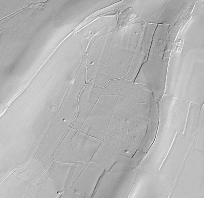
This image shows the LIDAR extract of the northern area of Adisham Woods with the prehistoric tumuli clearly marked (the little dimple towards the top left) as well as the regular boundaries of the earlier pre-Roman fields that underlie the present woods.

This picture is an extract from the aerial photo of the wood’s northern end just after WWII. This clearly shows the barrow following heavy woodland clearance for the war effort, and possibly for the local coalmines.